Powerful Winter Storms Blowing Through Western Colorado
Get your snow shovels ready, there will be two powerful winter storms blowing through eastern Utah and western Colorado this weekend.
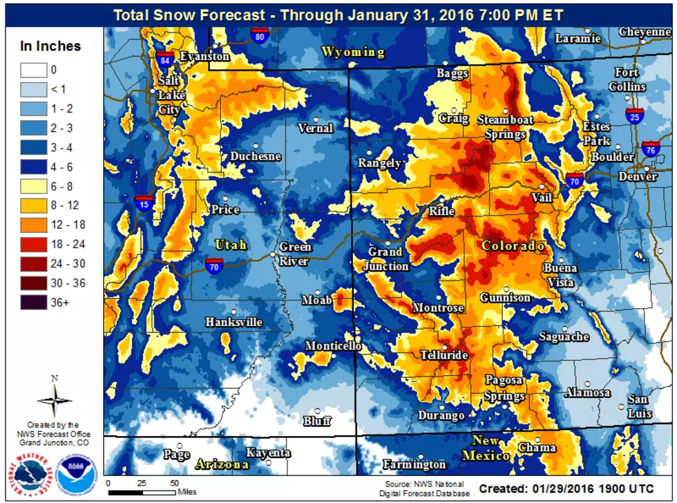
The first storm will arrive late this evening (Jan. 29) and continue through Saturday (Jan. 30). Looking at the graphic above, central mountains will take on most of the snow.
Heavy snow will move southward on Saturday with snowfall rates about two to three inches per hour lasting one to two hours.
For the first storm, the heavy snow will affect the following areas:
- US40 (Rabbit Ears Pass) -- Craig, Meeker, Steamboat Springs, Yampa -- Saturday morning.
- I-70 Corridor (Vail Pass) -- Aspen, Vail, Crested Butte -- Saturday afternoon.
- US550 (Red Mountain Pass) -- San Juan Mountains -- Saturday evening.
There will be strong winds accompanying this front from 30 to 50 mph, possibly reaching 60 mph.
The second storm will arrive in southeast Utah and southwest Colorado Sunday (Jan. 31) afternoon. This storm will rapidly spread northward Sunday night and encompass most of the region on Monday (Feb. 1) morning.
For the first storm, the heavy snow will affect the following areas:
- Southern Mountains -- two to three feet -- Molas and Coal Bank Passes and near Vallecito Reservoir.
- Southern Valley -- Durango, Pagosa Springs, Cortez, Blanding -- 12 inches plus.
Day 2 Map (Saturday through Sunday)

Day 3 Map (Sunday through Monday)

More From Mix 104.3